|
by Mike the Strike |
| Thermal
Soaring
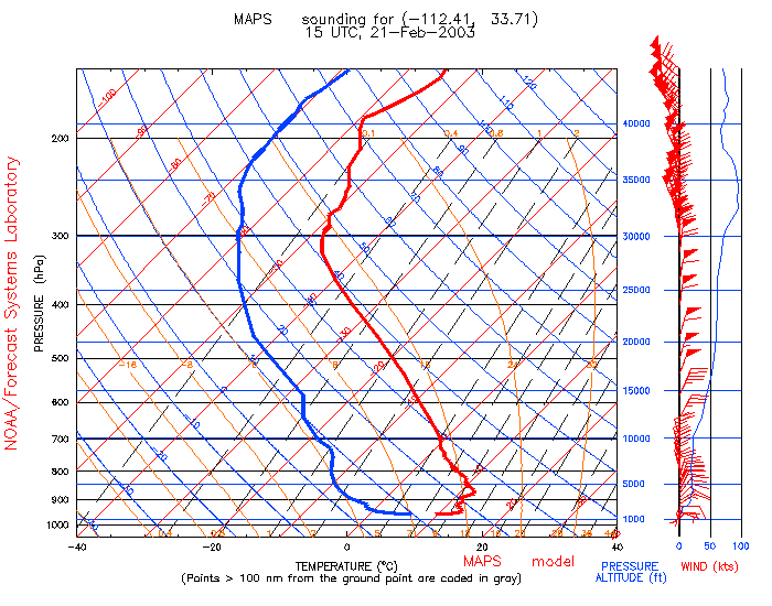
Thermal soaring is possible when buoyant air near the ground rises. The most common source of buoyancy is heating - the sun heats the ground, which then heats the air in contact with it. Given an initial stimulus, the heated air starts to rise. If the surrounding air is cooler than it, the warm air continues rising until it reaches the same temperature as its surroundings. Moist air tends to be less dense than dry air at the same temperature. This is why we sometimes find better thermals near lakes or water sources, sometimes quite tiny water holes. (Wet ground, on the other hand, doesn't heat up as quickly as dry ground and does not produce such good thermals.) Thermal soaring forecasts need predictions of the temperature and humidity profile of the airmass as well as some assumptions about solar heating. In the absence of actual measurements of atmospheric conditions, we have to rely on numerical forecasts. I rely mostly on the work of Dr. Jack Glendening and derive the most useful data from his website. I augment these with actual sounding data from Tucson and Flagstaff and numerical predictions from the MAPS program. Bear in mind that the predictions do not take into account smaller-scale local topography and use assumptions that might not be correct - for example, the moving in of a layer of high cloud that cuts off the sun. Skew-T charts The skew-T chart can be a bit intimidating to those who haven't attended a science class for a few years, however, it is really quite straightforward. The chart is designed to give a visual display of the key characteristics of the atmosphere near the ground, namely the vertical profiles of temperature and humidity. These parameters are key to predicting the stability of the air, including the likelihood and strength of any thermals, and the probability of clouds and precipitation. The solid red line in the chart below is the predicted temperature profile and the thick blue line the dew point. A parcel of warm air near the ground will rise if it is warmer than its surroundings - typically thermals start from a pool of warm air on the ground that gets disturbed. As the warm parcel rises, it expands and cools at a rate shown by the thin blue lines in the Skew-T chart that run from bottom right to top left (this is called the dry adiabatic lapse rate, for the techies). The air will rise until it reaches surroundings at the same temperature. For example, in the chart shown below, a parcel of air heated to 30 degrees C will rise until the thin blue 30 line intersects the actual air temperature - the thick red line-at about 11,000 feet. The strength of a thermal depends on just how much warmer it is than the surrounding air. Early in the day, the air near the ground will be cooler than later on as the sun warms it, however, the air above a thousand feet or so remains pretty much unchanged throughout the day.
Soaring forecasts typically show a simplified skew-T chart with the actual or forecast temperature sounding and the dry adiabatic lapse rate line for a temperature corresponding to the maximum expected for the day. The following example is a Tucson soaring prediction taken from the Soaring Forecast web site. This shows the intersection of the two curves at about 11,000 feet. The plot also shows numerical values of thermal index versus height. The height of the -3.0 thermal index is normally reckoned to be the usable top of lift for soaring - in this case about 8,500 feet.
---------------------------------------------------------------------
Forecast high taken from TUS
  21-FEB-2003 12 UTC  Soaring report from TUS upper air data.
   Forecast high: 69 F; est. base of any clouds: 7200 feet AGL.

                    === Raw Upper-Air Data ===
Feet MSL:   2585   2643   3054   3203   4807   5286   5513   9048   9965  10681
Pres mb:     923    921    907    902    850    835    828    725    700    681
Temp C:      4.4    4.6    5.4    7.4    6.8    6.2    7.6   -0.9   -2.1   -3.3
VirT C:      5.4    5.5    6.4    8.3    7.6    7.0    8.1   -0.5   -1.8   -3.1
DewPt C:     4.4    2.9    4.2    2.7   -0.2    0.2   -5.4  -10.9  -16.1  -20.3
Wdir@kts:                             340 13                      360 25

       === Interpolations (temps in deg. F, altitudes in feet MSL) ===
  MSL  *TI* Wdir@kts trig  VirT  2.0 degrees/division ("`": Dry Adiabatic)
-----  ---- -------- ---- . ---- -----------------------------------------
18000   6.9  335  33   81 |  0.5 `     :
17500   6.2            80 |  2.0  `    :
17000   5.6            79 |  3.6   `    :
16500   5.0            78 |  5.1     `   :
16000   4.4            77 |  6.7      `   :
15500   3.7            76 |  8.2       `  :
15000   2.8            74 |  9.2         ` :
14500   1.4            72 |  9.4          `:
14000   1.2            71 | 11.7           `:
13500   1.0            71 | 13.9             :
13000   0.7            70 | 16.1              :
12500   0.5            70 | 18.3               `:
12000   0.2            69 | 20.6                 :
11500  -0.0            69 | 22.8                  :
11000  -0.3            69 | 25.0                   :
10500  -0.7            69 | 27.0                    :`
10000  -1.3    5  25   68 | 28.6                     :`
 9500  -2.0            66 | 29.9                     : `
 9000  -2.7  355  27   65 | 31.3                      :  `
 8500  -3.0            65 | 33.5                       :  `
 8000  -3.3  355  29   64 | 35.7                        :  `
 7500  -3.5            64 | 37.9                         :   `
 7000  -3.8  355  26   63 | 40.1                          :   `
 6500  -4.0            63 | 42.3                           :   `
 6000  -4.3  350  23   62 | 44.5                             :   `
 5500  -4.7            61 | 46.5                              :   `
 5000  -6.9  350  18   58 | 45.2                             :     `
 4500  -8.0            55 | 45.8                             :       `
 4000  -9.3  320   8   53 | 46.2                             :        `
 3500 -10.5            51 | 46.7                              :        `
 3000 -13.9  220   5   45 | 43.2                            :            `


Back to main page
|
 Thermal Forecasting